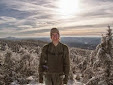
 Yesterday I hiked up the Greeley Ponds Trail, off Route 112, to collect samples from Lower (see pond photo below) and Upper Greeley Pond. Overall it was a wet day, with plenty of river and stream crossings and muddy trails. So far this summer seems to be shaping up like last, with lots and lots of rain. According to the National Weather Service, this June was one of the rainiest on record, with the average rainfall in June being about 2.3 inches,
 with this month probably around 7 or 8 inches.
Along the trail there was this impressive gnarly red maple, which has some how managed to latch onto a large boulder in the middle of the trail (see below).
After Greeley I sampled Lily Pond right off the road, and then headed to Church Pond, which is near the Passaconaway Campground. The trail starts at the edge of the campground and immediately requires a river crossing. The river (the swift river?) was clearly bloated from all the recent rain, with a surprisingly strong current (see photo below). I crossed this and continued on the trail, and then crossed another smaller river. From here the trail remains very flat weaving through an open mixed hardwood-conifer forest, before eventually turning into a miring mess of a pathway through a bog. The path eventually became too soggy to follow, with firm terrain becoming more and more scarce (see photo of the wetland below). Since I was alone, and lacked the proper equipment to trek through muck up to my  knee, for a distance I was not sure of, I chose to turn around and return on a drier day, better prepared for the bog conditions. I also sampled Falls Pond which is just up the hill from the scenic Rocky Gorge area on the Kancamagus.
 knee, for a distance I was not sure of, I chose to turn around and return on a drier day, better prepared for the bog conditions. I also sampled Falls Pond which is just up the hill from the scenic Rocky Gorge area on the Kancamagus.


No comments:
Post a Comment