Tuesday, December 5, 2017

Denali National Park


This was May 30, 2017, and winter was not through with Denali National Park yet. We spent the day exploring off-trail near the Savage River. We also visited the NPS sled dogs near the visitor center area. 


Cantwell, Alaska


When I visited my brother in Alaska he was living in the tiny town of Cantwell, just outside of Denali National Park. From his place we could walk to the Windy Creek Trail, which is accessed from a lumber road on private property through an easement. 


Jonathan and I explored a freshwater wetland, a wet meadow. Wetlands make up over 43% of Alaska's land surface area, or 130 million acres, which is 63% of the wetlands in the United States.


Alaska is a beautiful and incredibly inhospitable environment.


Sled dogs summer training! 


Moose track with dewclaw 


Monday, August 28, 2017

Denali National Park: Savage River Canyon


Back in May-June of this year, I visited my twin brother in Alaska. He was working at Denali National Park.
the landscape along the Savage River Canyon
One of the days we did a day hike along Savage River Canyon, the last spot in Denali you can drive to in a personal vehicle without reserving spots at one of the campgrounds further into the park. We bushwhacked past the short loop trail and explored the canyon on our own.


We watched a dall sheep misjudge the jump across the river. It bounced off one of the rocks and fell into the river. We were glad to see it appear fine when it managed to get out of the cold water, the only injury appeared to be to its ego. 


Caribou

we watched dall sheep jump the river for a couple of hours


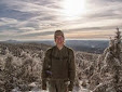
My brother in Savage River Canyon

Jonathan during the bushwhack 

Jonathan during the bushwhack 

Jonathan surveying the landscape of Mordor


One of the scariest things in my life (until two days later in Denali) occurred while we were off trail in the Savage River Canyon. I was leading us back to the real trail, I rounded some boulders and came upon a grizzly bear cub on the unofficial game/way trail. It was poking around the rocks, coming down the slope deeper into the valley, and it started walking unnervingly quickly towards us. We turned around and headed back the way we came, further into the Savage River Canyon, while we considered our options. Getting between a mother grizzly and her cub is extremely dangerous and is almost guarantees an attack from defensive mother. We realized the cub had somehow been separated from its mom, and we were likely between the mother (on the top of ridge somewhere) and the cub which eventually made its way to the bank of the Savage River.


We decided to not backtrack the entire way we came because our line of sight was very limited due to a large rock outcropping, and we didn't want to remain so close to the cub. We chose to go up and around the outcropping and then back down and then jog back to the trail. So we bushwhacked at a rapid pace up the slope of the ravine, looking for the mother bear while picking our path carefully  along the rocky uneven tundra. We had our bear spray out, but wind gusts were extremely high in our direction, meaning if we needed it, it would likely be ineffective (and hopefully not blow back in our faces). On top of the slope we paused to catch our breath and pick our route back down. The air blew hard, nearly knocking us off my feet. We scrambled down the slope and made our way quickly back to the trail we started at. While jogging back the way we came we spotted the silhouette of what appeared to be the mother grizzly on ridge line searching for its cub. 

The whole experience was extremely unnerving, and it felt great to be back to the trail head, well away from the cub

The landscape in Denali is beautiful and sparse


We spotted a golden eagle on the drive back


Moose are EVERYWHERE in Denali. I have seen plenty of Moose in NH and other parts of New England, but I have never seen so many in such a short period of time, there is definitely a much higher concentration in the Denali area. This moose cow was browsing vegetation with its calf carefully hiding in the nearby vegetation.


Carpenter Bee (Xylocopa virginica) at Saluda Shoals, SC


Tuesday, March 28, 2017

Bushwhack to Emmons Glacier in Mt. Rainier National Park

Unnamed Lake, Goat Island Mountain, and Emmons Glacier. I took this photo the previous day, from First Burroughs.

In the foreground is the unnamed lake south of Emmons Glacier. Emmons Glacier is below Little Tahoma (the rocky mountain) and a portion of Emmons Glacier is to the right. 

While visiting my twin brother at Mt Rainier National Park this past September, we bushwhacked to Emmons Glacier. This was after spending a night in the Fremont Lookout, and going up First and Second Burroughs, as well as bushwhacking partially up Goat Island Mountain. This meant we had the opportunity to view Emmons Glacier from unique perches high-up on both sides of the valley. This made the bushwhack to Emmons Glacier that much more interesting. 


The side of the glacial moraine in the valley where Emmons Glacier is


Jonathan during the bushwhack to Emmons Glacier
Initially we planned to go from the unnamed lake to the headwaters of the White River, then take the stream up the glacier. However, this route quickly became very dense and impassable. We ended up backtracking and eventually found a makeshift rock-cairn route along glacial boulders, which poked up above much of the conifers in the area, making the hike a bit easier.

I took this photo the previous day, from First Burroughs. The route we took during the bushwhack is approximately sketched in read. 


A spectacular view en route to Emmons Glacier


In front of Emmons Glacier

Jonathan looking  upon Emmons Glacier towards the end of the bushwhack

First and Second Burroughs and the Sunrise Rim trail ridge area, the edge of the glacial moraine to the left. The headwaters of the White River flowing from Emmons Glacier can be seen in the bottom right corner.
This hike afforded us spectacular views of the Burroughs Mountains, Mt. Rainier, Little Tahoma, Goat Island Mountain, and the surrounding landscape. Every step was breathtaking. We were fortunate to have a day of amazing weather, with no clouds in the sky. In fact, it was almost too sunny. Emmons Glacier itself was stunning. Standing at the base of the glacier, which was covered in rock and sediment, it gave off a feeling of immense power. I remember feeling a bit awe-struck, in a nervous way. Large ice chunks could be seen and heard breaking off in the center, crashing into the ground and forming the headwaters. We scrapped off a bit of sediment and touched the glacier ice, it was exciting!

Emmons Glacier, Little Tahoma above it and part of Mt. Rainier to the right. 

Me, Emmons Glacier, Little Tahoma above it and part of Mt. Rainier to the right. 

Me and Jonathan well in front of Emmons Glacier. The perspective of this photo makes the glacier appear small, but it is quite large.

An unnamed stream flowing into the valley
This hike was a fitting end to a fun week, which let us explore in-detail a large corner of Mt. Rainier National Park.