|
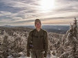
| Kermit and I on the way up Mt. Lafayette |
 |
| Kermit needed several breaks along the way! |
As part of my vacation, I headed to the White Mountain National Forest in NH, with Kermit for a few days. For Kermit's first real hike, we went up Mt. Lafayette (5,249 ft). Lafayette is the highest peak in the Whites outside of the presidential range. It was a good test for him, and for not having much hiking conditioning, he did a great job. Living in Illinois for a few years killed my hiking legs, so I think we were both a bit sore the next day.
 |
| Eagle Lake, along the side of Lafayatte |
 |
| The Greenleaf AMC hut |
 |
| It was a bit windy and chilly (as expected) in the krumholtz and alpine areas |
 |
| I took this photo off Bear Notch Road, heading to the Kancamagus. Bear Notch Road cuts through Bartlett Experimental Forest, where I did a great deal of field while working at a lab as an undergraduate at the University of New Hampshire. There are several of cutoffs along the road, with great vistas like this. Occasionally we would get to eat lunch at one, while en route to another study plot in the forest. |
When I stepped out onto the first ledge with a vista, I found the enormity of the view to be a little overwhelming. While living in Illinois for almost three years, I did not forget what the Whites looked like, but seeing them up close and personal is much different experience.
 |
The view from the Greenleaf AMC Hut. You can see the summits of Lafayette, Lincoln, and Little Haystack.
|
|
 |
| One of the great views along the Bridle Path |
 |
| Another vista off the Bridle Path |
 |
| (looking south) The Old Bridle Path follows the ridge line up Mt. Lafayette. Interstate 93 is visible. |
 |
| The Old Bridle Path, a very rocky and steep trail, typical of the White Mountains |
 |
| One of the tough spots on the trail for Kermit, slippery and sharp rocks. He did great though! |
 |
| Kermit was happy to rest on my lap for a few minutes on the way down |
 |
| Dinner was cooked using my homemade cat food can stove. |
It feels nice, albeit a bit odd to once again be driving on the curvy forested roads of New England, after a few years of driving on the straight roads in the wide-open landscape of Illinois. But I will miss the under-appreciated beauty of Illinois. One of my favorite things about Illinois is the large open sky, it's beautiful, and it can be quite incredible to witness thunderstorms in such a spacious landscape.
That night we car-camped off the Kancamagus, at the National Forest Hancock Campground. I opted not to back-pack this trip, since Kermit is still getting used to hiking mountains (but really...both of us need better conditioning!). We fell asleep to the pleasant rush of the Pemigewasset River.