 |
This beautiful little yellow pine chipmunk (Tamias amoenus) shared the view of the Berkeley Park area with me and my brother, from the Fremont Trail, on our way back from the tower to the Burroughs Mountains.
After waking up, enjoying the view, and immediately wanting to the leave the "fish bowl" that is Fremont Lookout (it's a popular hiking spot, especially on on such a nice day), we headed back down the Fremont Trail towards First and Second Burroughs Mountains. While there was still quite a bit of cloud cover, the views were spectacular, even though Rainier and Little Tahoma were back in the clouds for most of the hike out that day.
|
 |
| These photos were taken from the Fremont Trail and merged. On the far left, Frozen Lake is visible. Straight ahead is First and Second Burroughs, Third Burroughs is in the clouds, as is Rainier and Little Tahoma behind it. |
 |
| This is looking back up the Fremont Trail, where it was completely foggy the day before |
 |
| Along the Fremont Trail adjacent to Frozen Lake. First and Second Burroughs are straight and to the right |
 |
| Berkeley Park area, the Wonderland Trail cuts through this valley, the trail is faintly visible in this photo. Rainier is blocked by the clouds! |
 |
| Another view into Berkeley Park |
 |
| If you look carefully, on the third hump from the right, Fremont Lookout is just barely visible in the clouds. That's where we spent the previous night! |
 |
| Another view into Berkeley Park |
 |
| The view of the Inter Branch to White Fork River, from Second Burroughs |
 |
| Third Burroughs (and Rainier) is engulfed in clouds. |
The above photo was taken from the top of Second Burroughs. The trail stops along the slope of Third Burroughs, there's no trail to the summit. My brother, Jonathan, has been up it several times. At this point in our hike we were both hungry and tired (a mouse kept us up much of the night in the tower), and we opted to skip breakfast to hike and munch on snacks while moving. Those factors, combined with the cloud cover, we decided to continue on our way along the Sunrise Rim Trail, which takes us back to our vehicle, to form a big loop started yesterday.
 |
| Emmons Glacier!! Goat Island Mountain is the mountain above it. |
With the above photo, we had another perspective on Emmons Glacier. Two days earlier we saw it from the ridge on Goat Island Mountain (the mountain dominating the above photo), and now from First and Second Burroughs. The next day we get to see it up close and personal after bushwhacking to it! (next post!)
 |
| Jonathan on Sunrise Rim Trail, in the alpine tundra! |
 |
| Unnamed subalpine lake, White River, Emmons Glacier, and Goat Island Mountain. |
 |
| White River, Emmons Glacier, and Goat Island Mountain. |
 |
| Jonathan was telling about some of his (crazy) experiences on this sketchy trail, in the winter. |
 |
| Jonathan along the Sunrise Rim Trail. The White River is visible below. |
 |
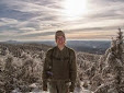
| Me on the Sunrise Rim Trail |
 |
| The trail is beautiful and more than a little sketchy, definitely not a place you want to lose your footing. |
 |
| An impressive stone overlook built by the CCC in the 1930s |
 |
| Me and Jonathan at an overlook on the Sunrise Rim Trail, built by the CCC in the 1930s |
 |
| Goat Island Mountain (right) and Emmons Glacier and White River (middle, below) |
 |
| Goat Island Mountain and White River |
 |
| unnamed pond along the Sunrise Rim Trail |
 |
| Jonathan cut this tree as part of his trail work. He's laughing because it's not the most impressive example of his work :-) |
 |
Taken from towards the end of Sunrise Rim trail (Emmons Glacier is visible)
|
 |
| This was taken towards the very end of the Sunrise Rim Trail. |


No comments:
Post a Comment